
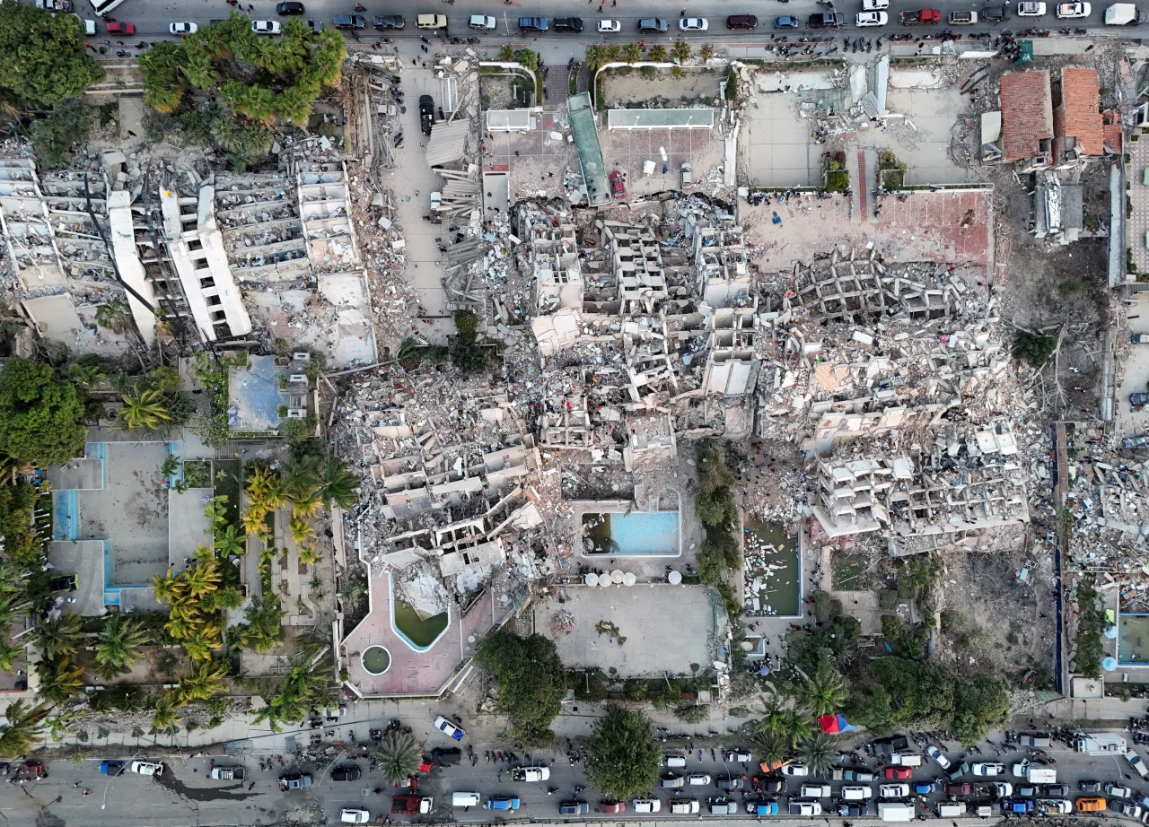
More than 1,700 people have died since last week’s devastating earthquakes in Venezuela.
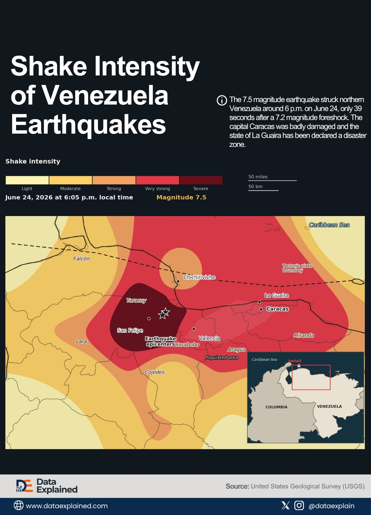
The 7.5 magnitude earthquake struck northern Venezuela around 6 p.m. on June 24, only 39 seconds after a 7.2 magnitude foreshock.
The capital, Caracas, was badly damaged, and the state of La Guaira has been declared a disaster zone.
To get a mental picture of this catastrophe, the graphic above is a shake intensity map showing earthquake epicenters near San Felipe, Yaracuy state.
The map is based on estimations from the United States Geological Survey (USGS).
TL;DR
- A magnitude 7.5 earthquake struck Venezuela on June 24, 2026, just 39 seconds after a 7.2 foreshock. A rare “doublet” event and the country’s strongest earthquake since 1900.
- At least 1,700 people have died, and more than 2,150 have been injured, with thousands still unaccounted for, and aftershocks are continuing to hamper rescue efforts
NOTE: This story is ongoing and developing.
| wdt_ID | wdt_created_by | wdt_created_at | wdt_last_edited_by | wdt_last_edited_at | Event | Latitude | Longitude | Depth (km) | Time (UTC) | Magnitude |
|---|---|---|---|---|---|---|---|---|---|---|
| 1 | emmanuel-ashemiriogwa | 30/06/2026 12:03 PM | emmanuel-ashemiriogwa | 30/06/2026 12:03 PM | Foreshock | 10 | -68.52 | 22 | 24/06/2026 10:04 PM | 7.20 |
| 2 | emmanuel-ashemiriogwa | 30/06/2026 12:03 PM | emmanuel-ashemiriogwa | 30/06/2026 12:03 PM | Mainshock | 10 | -68.00 | 10 | 24/06/2026 10:05 PM | 7.50 |
A Rare Double Strike
A magnitude 7.2 foreshock struck just after 6 p.m. local time on June 24.
Thirty-nine seconds later, a magnitude 7.5 mainshock followed, which the USGS calls a “doublet,” a rare phenomenon involving two major earthquakes of similar destructive energy in immediate succession.
The stronger of the two is the largest earthquake to strike Venezuela since 1900, when a 7.7 magnitude quake hit the country.
The doublet was possible because of the region’s specific geology.
Northern Venezuela sits within a broad, transpressional boundary zone between the Caribbean Plate and the South American Plate, rather than along a single fault.
That zone is wide and fragmented, capable of rupturing in multiple places within seconds (which is exactly what the map’s dotted plate boundary line, running along the coast, represents).
ALSO READ: The Most Earthquake-Prone U.S. States
Why Caracas Crumbled Anyway
The shake intensity map shows the capital sitting within a band of strong and very strong shaking despite its distance from the epicenter.
- Experts say buildings in Venezuela are more likely to collapse than structures in other quake-prone places, such as Japan or California, where building codes are more strictly enforced.
- Many buildings are also unlikely to have been retrofitted in line with modern earthquake regulations.
- In the hard-hit Altamira area of Caracas, many of the collapsed buildings were built on sediments, making them far more vulnerable to seismic waves.
- There’s also a lot of informal housing across the country that was never built to withstand a quake this strong.
The Numbers, and Their Limits
As search-and-rescue operations continue, at least 1,700 people have died, more than 2,150 have been injured, and thousands remain unaccounted for.
The USGS’s PAGER system, which models likely casualties from an earthquake’s seismic data, initially warned that the toll could rise significantly and that there was a substantial probability of exceeding 100,000.
The official figures have not moved smoothly.
After a 27 June update placed the death toll at 1,430, the next update 24 hours later added only 20 more deaths
The New York Times reported the toll may be a “substantial undercount,” and disaster experts from University College London and the University of Cambridge expect the number to climb further once more bodies are recovered from the rubble.
ALSO READ: Top 10 Countries Hit by The Most Earthquakes
Help Is Arriving
The United States deployed search-and-rescue teams from Fairfax County, Virginia, and Los Angeles County, while Mexico’s president announced the deployment of rescue teams and health personnel.
Search-and-rescue crews from Chile, the Dominican Republic, El Salvador, Spain and Switzerland have also arrived, and the U.S. State Department pledged $150 million in aid, including $100 million to a UN humanitarian fund for Venezuela.
The earthquake struck a country already navigating an acute political and economic transition.
The USGS map shows where the ground shook hardest. What it cannot show is how long it will take for Caracas and the surrounding region to recover.
ELI5 (Explain It Like I’m 5)
Two huge earthquakes hit Venezuela just 39 seconds apart, the strongest the country has felt in over 100 years.
The shaking happened near the coast, far from the capital city, Caracas, but a map shows the ground shook hard all the way there too, because the earthquake traveled along a long crack in the earth that runs near the coast.
More than 1,700 people have died. Many buildings weren’t strong enough to withstand the shaking, and more shaking could still occur.
Source:
United States Geological Survey (USGS) (Data as of June 26, 2026, 5:00 a.m. ET) | CNN | The New York Times