
An earthquake-prone state refers to a region or geographical area that has a high likelihood of experiencing significant seismic activity (earthquakes) due to its location near active fault lines or shifting tectonic plates.
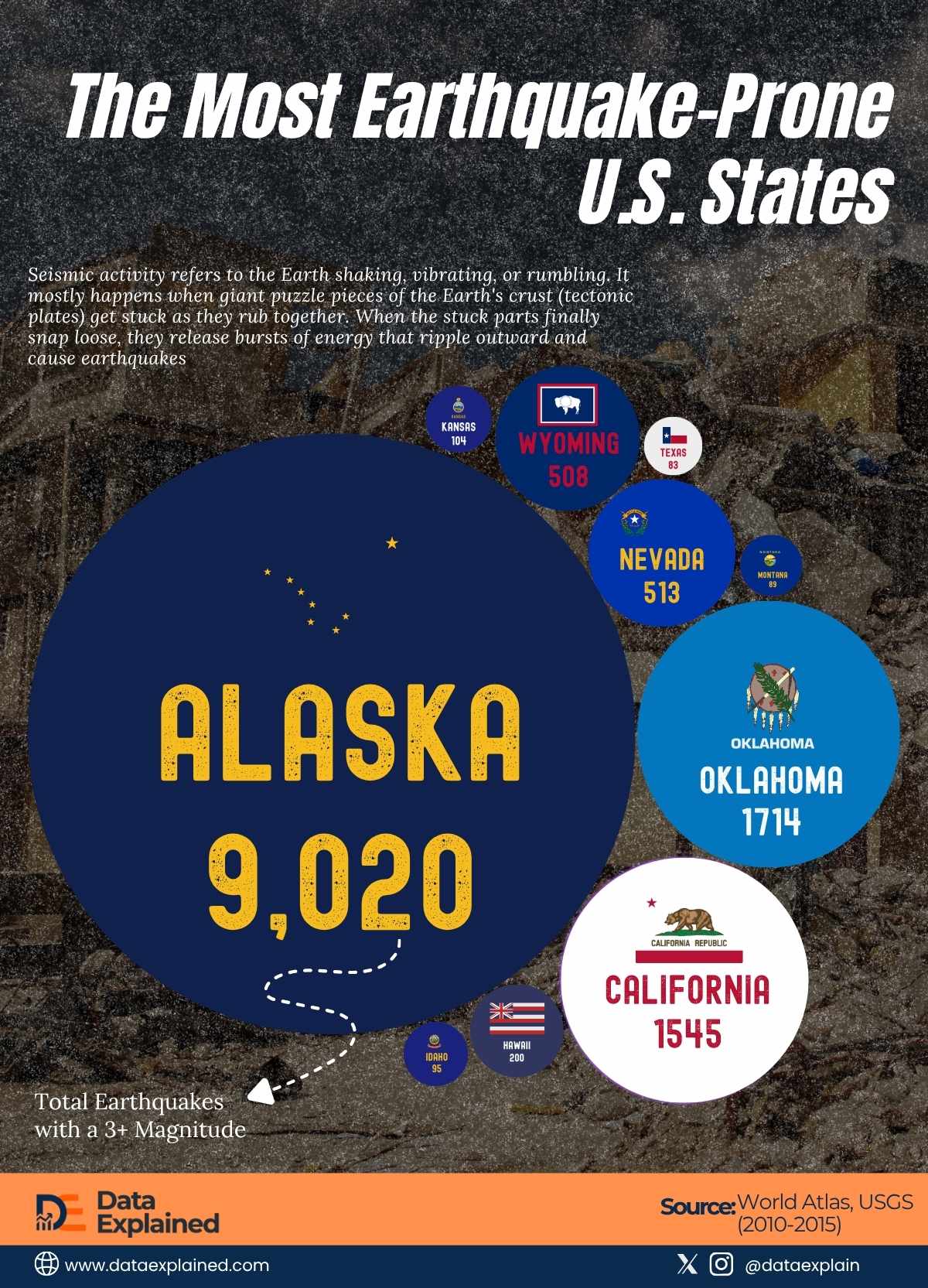
According to WorldAtlas, Alaska leads the U.S. in earthquake activity.
It is based on the total number of earthquakes with magnitudes over 3 between 2010 and 2015.
TL;DR
- Alaska and Oklahoma lead in earthquake-proneness across the U.S.
- Stronger buildings and better planning are needed to reduce damage and save lives.
Ranked: The Most Earthquake-Prone U.S. States
| wdt_ID | wdt_created_by | wdt_created_at | wdt_last_edited_by | wdt_last_edited_at | Rank | State | Total Earthquakes with a 3+ Magnitude (2010-2015) |
|---|---|---|---|---|---|---|---|
| 1 | Monica Ebunoluwa | 16/06/2026 02:31 PM | Monica Ebunoluwa | 16/06/2026 02:31 PM | 1 | Alaska | 9,020 |
| 2 | Monica Ebunoluwa | 16/06/2026 02:31 PM | Monica Ebunoluwa | 16/06/2026 02:31 PM | 2 | Oklahoma | 1,714 |
| 3 | Monica Ebunoluwa | 16/06/2026 02:31 PM | Monica Ebunoluwa | 16/06/2026 02:31 PM | 3 | California | 1,545 |
| 4 | Monica Ebunoluwa | 16/06/2026 02:31 PM | Monica Ebunoluwa | 16/06/2026 02:31 PM | 4 | Nevada | 513 |
| 5 | Monica Ebunoluwa | 16/06/2026 02:31 PM | Monica Ebunoluwa | 16/06/2026 02:31 PM | 5 | Wyoming | 508 |
| 6 | Monica Ebunoluwa | 16/06/2026 02:31 PM | Monica Ebunoluwa | 16/06/2026 02:31 PM | 6 | Hawaii | 200 |
| 7 | Monica Ebunoluwa | 16/06/2026 02:31 PM | Monica Ebunoluwa | 16/06/2026 02:31 PM | 7 | Kansas | 104 |
| 8 | Monica Ebunoluwa | 16/06/2026 02:31 PM | Monica Ebunoluwa | 16/06/2026 02:31 PM | 8 | Idaho | 95 |
| 9 | Monica Ebunoluwa | 16/06/2026 02:31 PM | Monica Ebunoluwa | 16/06/2026 02:31 PM | 9 | Montana | 89 |
| 10 | Monica Ebunoluwa | 16/06/2026 02:31 PM | Monica Ebunoluwa | 16/06/2026 02:31 PM | 10 | Texas | 83 |
Data Proves Popular Assumption Wrong…
When people think of earthquakes in North America, California is usually the first place that comes to mind. But the data tells a different story.
States like Alaska and Oklahoma experience even more seismic activity. Scientists have recorded thousands of earthquakes with a magnitude of 3.0 or higher.
Alaska tops the list as the most seismically active state in the U.S., with over 9,000 earthquakes.
This is because it lies directly on the Pacific Ring of Fire, where tectonic plates typically collide and subduct beneath one another.
Oklahoma comes next with 1,714 quakes. Although natural plate movements do not cause it, human activity, such as wastewater injection, does.
California, known for the San Andreas Fault, comes third with 1,545 earthquakes. It’s not the highest, but the state’s dense population makes its quakes intense.
- Over 500 quakes that happen in Nevada and Wyoming are mostly tied to tectonic faults in the western U.S.
- Approximately 200 earthquakes in Hawaii are mainly caused by volcanic activity beneath and around the islands.
- States like Kansas, Montana, Idaho, and Texas make up the top ten, showing that earthquakes aren’t only a West Coast issue.
The West Coast and Alaska face the most significant natural seismic risks due to their proximity to tectonic boundaries. The quakes in the Central U.S. tell how human activity can also trigger earthquakes.
The Pacific Margin: San Andreas, Cascadia & Alaskan Subduction Zones
Most of North America’s seismic activity happens along the Pacific Margin. There, tectonic plates grind, collide, and slide past one another.
Three major faults for this are:
San Andreas Fault (California)
The San Andreas Fault is a boundary where the Pacific Plate and the North American Plate slide horizontally past each other.
It is responsible for most of California’s quakes, including the 1906 San Francisco earthquake.
Most quakes are moderate; the risk of a significant event, sometimes called “the Big One,” is a primary concern due to California’s dense urban areas.
Cascadia Subduction Zone (Pacific Northwest)
The small Juan de Fuca Plate is located beneath the North American Plate, approximately 700 miles away.
Unlike the San Andreas, Cascadia produces fewer quakes, but when it does rupture, it can unleash mega-earthquakes of about 9+ magnitude and tsunamis.
The last significant event happened in 1700, and scientists warn that another could occur in the future.
Alaskan Subduction Zone:
Alaska is the most seismically active region in North America. It has produced more than 9,000 quakes between 2010 and 2015.
Here, the Pacific Plate is forced under the North American Plate along the Aleutian Trench. This zone was the epicenter of the 1964 Great Alaska Earthquake, which had a magnitude of 9.2.
This is the second-largest ever recorded worldwide.
Its quakes can generate tsunamis that can affect the wider Pacific.
Why Plate Boundaries See More Activity
Usually, earthquakes cluster around the edges of tectonic plates. One of these boundaries is North America’s west coast. This explains why it is the continent’s earthquake hotspot.
Plate boundaries are where the Earth’s crust is under the most tremendous stress.
This is why regions along the Pacific Ring of Fire (i.e., from Alaska down through California) see the highest occurrence of earthquakes in North America.
Less Obvious Areas: What Makes Intraplate Quakes Possible?
While most U.S. earthquakes occur along the Pacific coast, data from WorldAtlas show that seismic activity is not limited to California and Alaska.
A few states also rank among the top hotspots:
- Oklahoma (1,714 quakes, 2010–2015): Once a quiet seismic region, Oklahoma has recently experienced a surge in earthquakes.
- Kansas (104 quakes): Though quite far from plate boundaries, it is known to have enough activity to rank in the top 10 states for quakes.
- Texas (83 quakes): Texas is also part of the list, indicating that the continent’s interior is not exempt from shaking.
These “intraplate” earthquakes show that seismic risks are not confined to the West Coast alone.
ELI5
Let’s say the Earth’s surface is covered in giant, cracked, puzzle pieces (tectonic plates) that are always moving very slowly. When these plates meet, they don’t just slide smoothly; they often get stuck together due to friction.
As the plates continue to move, they bend and accumulate significant stress or energy in the rocks.
Eventually, the stuck parts can’t hold on anymore. They suddenly snap or slip, releasing all that stored-up energy as earthquake waves that shake the ground.
Because the West Coast is where the edges of these huge tectonic plates rub and grind, it has more places where plates get stuck and then release their energy, leading to most of the earthquakes.
Source: